Why do the trade winds and weather systems rotate in opposite directions?

  • Thread starter peteb
  • Start date
  • This site may earn a commission from merchant affiliate links like Ebay, Amazon, and others.

peteb

Poster Extraordinaire
Joined
Apr 25, 2003
Posts
7,406
Location
Cascadia
Of course we all spend of time wondering why the west is so dry and the east is humid. All deserts in North America lie west of the Rockies, less than 10 inches of annual precipitation. An older definition considered the Great Plains as a treeless desert unsuitable for farming.

the prevailing winds are from the west and should bring moisture, which they do, but only to the edge of the continent.

the reason for the western desert and the eastern humidity is that the Gulf Stream brings warm water north along the east coast while the California current brings cold water down the west coast. Warmer water means more evaporation and more humidity.

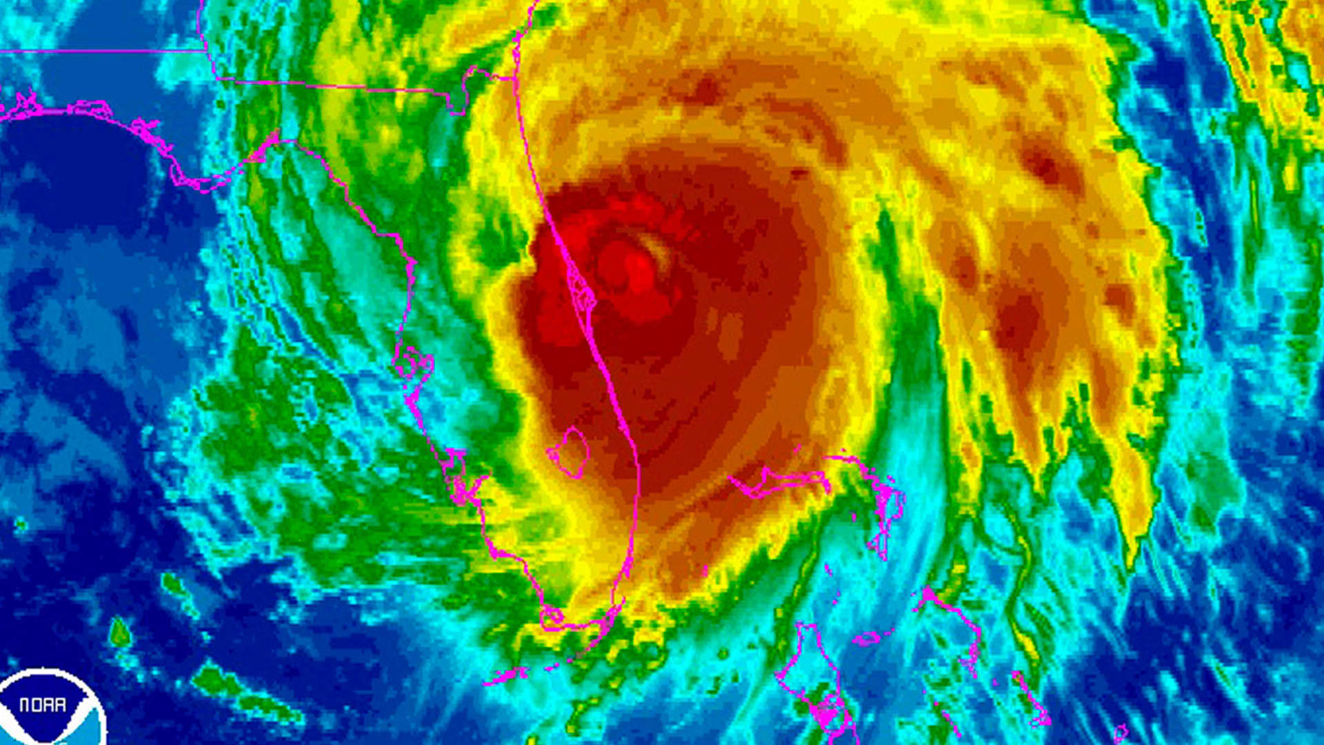
the coriolis effect is used to explain trade winds, ocean currents and weather systems including hurricanes.

north and south of the equator rotate in opposite directions for all three phenomena. The western edge of all continents receive the colder water, north or south. The western edges of continents, in the mid latitudes, 30-60, receive moisture from the prevailing winds.

here is the odd part and the source of the confusion.

weather patterns in the northern hemisphere normally rotate CCW, unless there are disruptions. Clock wise in the Southern Hemisphere.

maybe this is the answer. Watching the wind flow on weather websites, the weather patterns seem to go opposite of the expected direction quite a bit of the time. It is only when a huge system comes through that you can expect it to flow in the normal counter clockwise direction in the northern hemisphere.

here is the odd part,

trade winds and ocean currents in the northern hemisphere rotate clockwise, backwards from weather systems. I.e. the California current flows south, that is clockwise and the Gulf Stream travels north, that is clockwise.


how can it be?
 

schmee

Telefied
Ad Free Member
Joined
Jun 2, 2003
Posts
31,222
Location
northwest
Having sailed through both of these:
Why is the Gulf Stream traveling North considered Clockwise? It moves North or East at times but it has land masses making it do so... I guess you mean the Atlantic circular clockwise pattern overall?
The California Current travels South along the coast and not circular at all really...right? ... other than typical back eddies or etc. But is picked up by the N. Equatorial and carried West.
The prevailing winds off the Pacific do travel generally from the West in the upper Northern Hemisphere and can be quite humid, but I think having to move over the Rockies loses moisture...

Weather is very confusing for sure...
 

Dave Hicks

Poster Extraordinaire
Joined
Mar 28, 2003
Posts
5,449
Location
Hoosierlandia
Currents and winds are pulled to the right in the northern hemisphere, and to the left in the southern hemisphere. (Left and right are defined in terms an observer moving along with the wind/current.) Coriolis effect is minimal near the equator.

1647201614085.png


https://www.nationalgeographic.org/encyclopedia/coriolis-effect/

D.H.
 
Last edited:

peteb

Poster Extraordinaire
Joined
Apr 25, 2003
Posts
7,406
Location
Cascadia
Why is the Gulf Stream traveling North considered Clockwise?
It goes north along the us coast, trade winds go east toward Europe, then south, the trade winds west are south of the ones going east, then back up the coast. That is clockwise.
The California Current travels South along the coast and not circular at all really...right? .
The CC goes down the west coast, trade winds and current go west, then north, then east, then back south again. Clockwise. I will post a picture.
Currents and winds are pulled to the right in the northern hemisphere, and to the left in the southern hemisphere. (Left and right are defined in terms an observer moving along with the wind/current.) Coriolis effect is minimal near the equator.
This jibes with the rotation of the weather system, but not the overall flow of the trade winds and ocean currents, which affect dryness and humidity.
here's a good interactive world map- wind/currents, etc..
this shows the current large weather system off of the PNW coast, rotating counter clock wise, as it should, but notice it is opposite of the California current, which goes south along the coast.


trade winds
49DF97C8-D3F9-4CDE-9607-2886822FECBA.png


map of the ocean currents:

F88B8E8C-62DB-437E-B87A-5C75A0CBAF7E.jpeg

Map of the trade winds EDIT: It was supposed to be the trade winds, but it looks like the ocean currents.

9C2465A1-F3F8-4612-A839-6EA3F4C92217.jpeg

Turtles yesterday:

9D81EAB4-0C95-4C34-9C93-0DA3BD48C4E7.jpeg


“In fact, tropical cyclones — the general name for the storms called typhoons, hurricanes or cyclones in different parts of the world — always spin counterclockwise in the Northern Hemisphere, and spin in the opposite direction in the Southern Hemisphere.”


my point is that weather systems including hurricanes spin counter clockwise in the northern hemisphere, and clockwise in the Southern Hemisphere.

the maps of the world, above, show trade winds and ocean currents rotating clockwise in the northern hemisphere and counter clockwise in the Southern Hemisphere.


thank you for all input

i will try not to lose too much sleep over this.


This, this is supposed to be the ocean currents, from National Geographic.

78211DB1-08DC-4DDE-A3E6-DCB4AE619F12.png
 
Last edited:

peteb

Poster Extraordinaire
Joined
Apr 25, 2003
Posts
7,406
Location
Cascadia
This is a map of the trade winds, from NOAA. Similar, a little different, to the ocean current. I believe that basically the trade winds and the ocean currents are in the same places, and that most likely the trade winds cause the ocean currents.

B80FF4F1-96D7-4072-884B-064C97B8944D.png
 

peteb

Poster Extraordinaire
Joined
Apr 25, 2003
Posts
7,406
Location
Cascadia
Wind is one of three major factors causing ocean currents:


Ocean currents are driven by wind, water density differences, and tides.

Oceanic currents describe the movement of water from one location to another. Currents are generally measured in meters per second or in knots (1 knot = 1.85 kilometers per hour or 1.15 miles per hour). Oceanic currents are driven by three main factors:

1. The rise and fall of the tides. Tides create a current in the oceans, which are strongest near the shore, and in bays and estuaries along the coast. These are called "tidal currents." Tidal currents change in a very regular pattern and can be predicted for future dates. In some locations, strong tidal currents can travel at speeds of eight knots or more.

2. Wind. Winds drive currents that are at or near the ocean's surface. Near coastal areas winds tend to drive currents on a localized scale and can result in phenomena like coastal upwelling. On a more global scale, in the open ocean, winds drive currents that circulate water for thousands of miles throughout the ocean basins.

3. Thermohaline circulation. This is a process driven by density differences in water due to temperature (thermo) and salinity (haline) variations in different parts of the ocean. Currents driven by thermohaline circulation occur at both deep and shallow ocean levels and move much slower than tidal or surface currents.
 

Oxidao

Tele-Afflicted
Silver Supporter
Joined
Feb 6, 2013
Posts
1,690
Age
61
Location
PNA, Spain
I don't know exactly what is meant here by weather systems.
I suppose it must be the whole set of High Pressure systems and Low Pressure systems (with different fronts in between).
High Pressures move clockwise and Low Pressures ccw in northern Hemisphere (the opposite in the southern H).
Trade winds, they follow the rule of the Highs to turn right due to Coriolis fx.
The only weather system I know moving opposite to Trade Winds, are Low Pressure Systems.
The fluid is Air, and there is not obstacles.


weather patterns in the northern hemisphere normally rotate CCW
I think it is this what I can't see.
As far as I know, it is only Low Pressures moving CCW
 

schmee

Telefied
Ad Free Member
Joined
Jun 2, 2003
Posts
31,222
Location
northwest
It goes north along the us coast, trade winds go east toward Europe, then south, the trade winds west are south of the ones going east, then back up the coast. That is clockwise.

The CC goes down the west coast, trade winds and current go west, then north, then east, then back south again. Clockwise. I will post a picture.

This jibes with the rotation of the weather system, but not the overall flow of the trade winds and ocean currents, which affect dryness and humidity.

this shows the current large weather system off of the PNW coast, rotating counter clock wise, as it should, but notice it is opposite of the California current, which goes south along the coast.


trade winds
View attachment 961621


map of the ocean currents:

View attachment 961622
Map of the trade winds EDIT: It was supposed to be the trade winds, but it looks like the ocean currents.

View attachment 961623
Turtles yesterday:

View attachment 961624

“In fact, tropical cyclones — the general name for the storms called typhoons, hurricanes or cyclones in different parts of the world — always spin counterclockwise in the Northern Hemisphere, and spin in the opposite direction in the Southern Hemisphere.”


my point is that weather systems including hurricanes spin counter clockwise in the northern hemisphere, and clockwise in the Southern Hemisphere.

the maps of the world, above, show trade winds and ocean currents rotating clockwise in the northern hemisphere and counter clockwise in the Southern Hemisphere.


thank you for all input

i will try not to lose too much sleep over this.


This, this is supposed to be the ocean currents, from National Geographic.

View attachment 961628
Yeah, Semantics I guess. 👍 Having sailed the Cal Current, Gulfstream, Pacific North Equatorial current, Atlantic N. Equatorial Current, you threw me off with the 'Gulf Stream' rotating clockwise!
As your chart shows the Cal current goes south and is only on the coast. The N. Equatorial goes on from there. etc
Gulf Stream is pretty much coastal too, then becomes the N. Atlantic current. etc
I get it , when you patch them together you get a circle of sorts!
 

Harry Styron

Friend of Leo's
Joined
Aug 2, 2011
Posts
4,355
Location
Branson, Mo
If you row a boat, look at the eddy swirling around your left oar and eddy swirling in the opposite direction around your right oar.
 

24 track

Telefied
Ad Free Member
Joined
Nov 6, 2014
Posts
25,029
Location
kamloops bc
its simpler than you think , moisture comes off the pacific the clouds are heavey and dump the majority of its contents climing up the coast range and the Rockies , on the other side of these ranges there are winds and dry belts.
Then the north american shield plateaus out and as the north winds come down picking up residual moisture off the land , the cold air periodically rises above the warm southern air and pushes the cold way up into the atmosphere , this causes Hail, and tornados where the warm air finds a way to push up through the cold convection and creates a corialis effect, ( similar to the dead wind in the eye of a huricane) this usually happens in tornado alley on the Prairies.
Because the earth is on a 23 degree tilt and oscillates up and down in its orbit to the sun, certain times for 6 month approximately each hemisphere is in closer proximity to the sun , this is why in the far north we get 24 sunlight with 60-70 degrees temps in the arctic. in the summer,( of course at the equator it will maintain 12 hrs day/night all year long) . The oposite hemisphere will be in winter.

Ocean currents move with the winds respectively and again controlled by land masses , seasons.

It is intersting to note that Megadont sharks, are believed to have gone exstinct at the same time as the north /south American land bridge was formed ( approximately ) because there was a massive reshifting in oceanic currents ( one theory has it)

this is an approximation because of orbital anaomallies, and is not exact year by year .

its all in balance, the way it should be!

Add this to @peteb post #8 and there you have it .
 
Last edited:

peteb

Poster Extraordinaire
Joined
Apr 25, 2003
Posts
7,406
Location
Cascadia
High Pressures move clockwise and Low Pressures ccw in northern Hemisphere (the opposite in the southern H).
Thanks that helps explain part of it.

web check:
Winds blow away from high pressure. Swirling in the opposite direction from a low pressure system, the winds of a high pressure system rotate clockwise north of the equator and counterclockwise south of the equator.


the answer then appears that the trade winds behave like a high pressure system, opposite of a low pressure system.

I wonder why that is.


one difference I noticed between weather systems and trade winds. The trade winds are bounded by the continents while weather systems are not.
 

chris m.

Doctor of Teleocity
Joined
Mar 25, 2003
Posts
12,573
Location
Santa Barbara, California
All of it is driven by differential heating on the surface of the Earth, combined with the rotation of the Earth, gravity, and the influence of the Moon's gravity working sometimes with and sometimes against Earth's gravity. Ocean and wind circulation patterns are further affected by the bathymetry of ocean basins and the "bathtub walls" created by the continents. Differential density of sea water caused by differential temperature and salinity also plays an important role. A good physical oceanography textbook will go over all of these fundamental concepts. I found this one-- looks like it might be available for free, on line.

One thing to note about ocean currents and circulation is that the maps you've depicted are generally incomplete because they are showing surface currents. There has to be a total balance of water volume everywhere. So for example, all that water moving north in the Gulf Stream tends to sink when it gets off Labrador, forming the North Atlantic Deep Water, creating a balancing counter flow from the pole-southward.


Here's a quick quote from the Wiki on North Atlantic Deep Water--

In the conveyor belt model of thermohaline circulation of the world's oceans, the sinking of NADW pulls the waters of the North Atlantic drift northward. However, this is almost certainly an oversimplification of the actual relationship between NADW formation and the strength of the Gulf Stream/North Atlantic drift.[4]

NADW has a temperature of 2-4 °C with a salinity of 34.9-35.0 psu found at a depth between 1500 and 4000m.

This is a fairly classic Phys-O text:

1647282474261.png
 

peteb

Poster Extraordinaire
Joined
Apr 25, 2003
Posts
7,406
Location
Cascadia
I don't know exactly what is meant here by weather systems.
I suppose it must be the whole set of High Pressure systems and Low Pressure systems (with different fronts in between).
High Pressures move clockwise and Low Pressures ccw in northern Hemisphere (the opposite in the southern H).
Trade winds, they follow the rule of the Highs to turn right due to Coriolis fx.
The only weather system I know moving opposite to Trade Winds, are Low Pressure Systems.
The fluid is Air, and there is not obstacles.
Thanks Oxidao,

you were right on.

the web check I quoted above goes a little farther explain it.

in low pressure systems the wind is blowing toward the center, (possibly more destructive), and in high pressure the wind is blowing away from the center, thus explains a left hand turn versus a right hand turn.

looking at wind flow, the difference is subtle.


right now there are low pressure systems in the pacific and I see at least one notable high pressure system in the Atlantic.

it is subtle, but in the high pressure system, wind vectors appear in the middle, in the low pressure systems, wind vectors disappear in the center of the system.

that’s what I like about nature, stuff makes sense.
 

peteb

Poster Extraordinaire
Joined
Apr 25, 2003
Posts
7,406
Location
Cascadia
All of it is driven by differential heating on the surface of the Earth, combined with the rotation of the Earth, gravity, and the influence of the Moon's gravity working sometimes with and sometimes against Earth's gravity. Ocean and wind circulation patterns are further affected by the bathymetry of ocean basins and the "bathtub walls" created by the continents. Differential density of sea water caused by differential temperature and salinity also plays an important role. A good physical oceanography textbook will go over all of these fundamental concepts. I found this one-- looks like it might be available for free, on line.
Thanks Chris. It makes good sense.

I was reading a web article about where the water from the Columbia River went. They said as far north as the strait of Juan de Fuca and as far south as San Francisco, which is farther, showing a prevalence of south bound flow.

that seemed understandable, however, the article said the weather changed every few days, (probably north to south and south to north), and the surprising part is they said the direction of the ocean current changed with the wind direction.

I was thinking that an ocean current was more like DC than AC.
 
Top